Tap or Click the Buttons on the Right for Useful Links and Interesting Webcams
Tap or Click the Thumbnails Below for Information About the Trail System
The Trails Map , Bike Map , Aerial View and Distance Chart are PDF Format and Free
YouTube Provides Trail Samples and Vimeo Provides Interesting Movie Clips
Google Maps and Municipal Maps Provide Additional Mapping Information


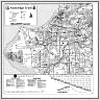
Trails Map

Bike Map
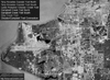
Aerial View