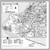
Trails Map

Bike Map
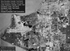
Aerial View
Description: Tony Knowles Coastal Trail hugs the coastline of Cook Inlet from 2nd Ave and H St Downtown 10.5 miles Southwest to Kincaid Park. This tour starts at Westchester Lagoon and ventures 9.25 miles Southwest to Kincaid Park. The trail is marked by mileposts every 1/2 mile, beginning at 2nd Ave and H St, increasing as you travel Southwest. The trail skirts Anchorage Airport at Pt Woronzof and low flying aircraft are frequently seen. The trail becomes more remote as you travel Southwest of Pt Woronzof. There are significant grades on the approaches to Earthquake, Pt Woronzof and Kincaid Parks. The other section of the Coastal Trail is presented separately under Coastal North.
Connections: From the Southwest Trailhead, paved paths adjacent to Raspberry Rd, Sand Lake Rd and West Dimond Blvd lead to the Southwest Trailhead of Campbell Creek Trail at West Dimond Blvd and Northwood Dr 6.35 miles away. The Coastal Trail intersects with Chester Creek Trail at Westchester Lagoon. There are numerous dirt trails in Kincaid Park.

(Tap or Click)
Highlights & Resources
-
Views of Cook Inlet, Mountains Ranges & Downtown Anchorage
-
Bears, Moose, Small Mammals, Ducks, Geese, Birds & Beluga Whales
-
Several Bridges
-
Alaska Railroad Underpass
-
Chester Creek Outfall Viewing Platform
-
Close Encounters with Low Flying Aircraft
-
Margaret Eagan Sullivan Park/Westchester Lagoon, Lynn Ary Park, Earthquake Park, Point Woronzof Park, Point Campbell Park & Kincaid Park
-
Paved Trail, Some Significant Grades & Marked by Mileposts
-
Kincaid Park Trail Map
-
Kincaid Park Singletrack Trail Map
-
Kincaid Park Ski Trail Map