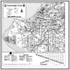
Trails Map
Bike Map
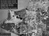
Aerial View
Description: Campbell Creek Trail parallels Campbell Creek from West Dimond Blvd and Northwood Dr 7.5 miles Northeast to University Lake. The trail is marked by mileposts every 1/2 mile, beginning at West Dimond Blvd and Northwood Dr, increasing as you travel Northeast. This tour starts at the 54th Ave and Old Seward Hwy Trailhead and ventures 3.5 miles Northeast to University Lake. The trail has a few minor grades; however, it is well suited to the novice user. Campbell Creek flows Southwest so traveling Northeast is generally more strenuous. To safely cross Lake Otis Pkwy, use the Traffic Light or Pedestrian Tunnel located three blocks South at Waldron Dr. The other section of Campbell Creek Trail is presented separately under Campbell South.
Connections: Campbell Creek Trail intersects with Chester Creek Trail at University Lake. Turn right at University Lake. Campbell Creek Trail intersects with the Old Rondy Trail adjacent to the Doctor Martin Luther King Jr Ave Underpass. This dirt trail leads to Campbell Creek Science Center, Campbell Tract Trails, Far North Bicentennial Park Trails and Hillside Trails. Other trails, adjacent to University Lake, lead to University of Alaska, Anchorage and Alaska Pacific University.

(Tap or Click)
Highlights & Resources
-
Scenic Views of the Chugach Mountains & Forested Areas
-
Moose, Small Mammals, Ducks, Geese, Birds & Fish
-
Numerous Bridges & Underpasses
-
Bancroft Park, Campbell Park, Chuck Albrecht Softball Complex & University Lake Park
-
Paved Trail, Minor Grades & Marked by Mileposts
-
Campbell Tract Trail Map
-
Far North Bicentennial Park Trail Map
-
Hillside Trail Map
-
Hillside Singletrack Trail Map
-
University Lake Park Trail Map